


The Mingan Archipelago National Park lies on a lonely stretch of coast in the northeast corner of North America. Nearly five centuries have passed since Jacques Cartier first laid anchor nearby, when the Atlantic coast teemed with wildlife. The landscape remains unmarred by the signatures of modern life, though the raucous chorus of seabirds that used to nest in unimaginable numbers is gone, as are the lumpy congregations of walrus along the shores.
The Mingan Archipelago National Park lies on a lonely stretch of coast in the northeast corner of North America. Nearly five centuries have passed since Jacques Cartier first laid anchor nearby, when the Atlantic coast teemed with wildlife. The landscape remains unmarred by the signatures of modern life, though the raucous chorus of seabirds that used to nest in unimaginable numbers is gone, as are the lumpy congregations of walrus along the shores. The fishing vessels have all but vanished, as has the Aboriginal presence – the plumes of smoke rising from summer camps, Innu hunters putting in their nets from birch bark canoes.
From the mainland I could see the islands, but not the park’s signature limestone monoliths – fantastical creatures carved out over millions of years by the motion of waves and ice. I also couldn’t see the lichen-draped trees, the tide pools bejeweled with sea stars and anemones, or the plant life found nowhere else on Earth. A ribbon of fast-moving whitewater marked the estuary where the Romaine River empties into the Gulf of St. Lawrence after coursing through 500 kilometres of canyons, forested valleys and wetlands from its headwaters on the Labrador plateau.
It was early June 2012 when I visited Mingan and the salmon were running, returning to their spawning beds on the Romaine. Almost every river on the Atlantic coast of North America once supported salmon, all distinct breeds adapted to unique conditions over millennia. Today, only a few of the rivers in the northeastern corner of the continent, in Québec and Labrador, have not been dammed or silted by deforestation and other industrial activity. It turns out that the almighty Salmo salar – aka Atlantic salmon, which the Romans called the “jumper” because it could muscle its way against powerful currents with little food or rest – cannot tolerate the subtlest chemical contamination of its waters. It will not suffer the indignity of being herded on barges and through culverts, or being raised in hatcheries. Only forested riverbanks and clear, cascading streams will do.
Soon salmon will be making their ancient journey up the Romaine for the last time.
One of Québec’s longest and wildest rivers, the Romaine is also the site of the second largest construction project in Canada. Hydro- Québec’s $8-billion Romaine Complex – part of the provincial government’s Plan Nord, a 25-year development strategy for northern Québec – will ultimately involve four large hydroelectric dam stations, a series of dikes, canals and spillways, and hundreds of kilometres of reservoir, roads and transmission lines. The Romaine-2 hydroelectric station was well underway by 2011; by the summer of 2012, Hydro-Québec was proceeding to dam the Grandes Chutes, a magnificent 27-metre cataract that formed a barrier falls for the salmon and served as an icon of Quebec’s unspoiled wilderness.
To get to the Romaine, I travelled almost 1,300 kilometres from Burlington, Vermont, most of the way along Route 138, a mountainous two-lane highway that follows the St. Lawrence River from Québec City almost to the Labrador border. The state of Vermont relies on Hydro-Québec for a third of its electricity, and yet few Vermonters have ever made the journey to the source of those electrons in the big, raging rivers of the north. I had come to meet with members of the communities that have been displaced by dams throughout the region, and to see the Grandes Chutes before they were gone forever.
About 250 km northwest of Québec City, Route 138 crosses the Saguenay fjord, beyond which is the land that the Innu people call Nitassinan. Not to be confused with their Inuit neighbors to the north, the Innu people live in 13 different communities that are politically divided by the Québec-Labrador boundary, most of them at the mouths of the rivers flowing into the St. Lawrence and the Atlantic. The Innu once crisscrossed the coastal mountains into the boreal forest and taiga as far west as James and Hudson bays, and as far north as Ungava. They are a forest-dwelling people who once lived primarily by the caribou, roaming freely by foot and canoe in the company of the animals and their spirits.
Nitassinan is now the land of Big Hydro. Large rivers like the Manicouagan, Outardes, Betsiamites and Sainte-Marguerite once tumbled over countless rapids as they descended from the lakes, streams and bogs of the Labrador tablelands toward the Gulf. The dams installed on those four rivers and their tributaries during the second half of the 20th century represent almost half of the hydroelectricity produced in Québec. When the Romaine complex is complete in 2020, Hydro-Québec’s reservoirs throughout the province will cover an area almost the size of the state of Vermont. That power goes to the aluminum smelters on the north shore, and to southern Québec, Ontario and the northeastern US, contributing to what is far and away the largest electricity grid in North America.
Hydro-Québec’s development of the Romaine was able to proceed through the planning and permitting process with little public opposition from the Innu communities, which had signed three separate compensation agreements in 2008 and 2009. Only Uashat and Mani-Utenam – two communities located 200 kilometres from the Romaine and represented by a single band council – obstructed the project by filing a court injunction in 2009. The band argued that the transmission lines would cut through the heart of their ancestral lands.
In the spring of 2012, while the transmission corridor construction proceeded without consent from the community, some two hundred Innu blockaded Route 138 in protest. All of the trucks carrying supplies to the dam construction site use this road. After four days, a phalanx of riot police wielding helmets, shields and batons moved in to break up the barricade. Women, children and elders cried and embraced one another. Some were carried off to jail.
The turnoff from Route 138 to Mani-Utenam is normally easy to miss, but I knew I’d arrived when I stumbled upon a large roadside encampment. A collection of canvas and spruce-pole tents, patched with pieces of blue tarp, were clustered around a larger, saddle-shaped tent called a shaputuan, which an Innu man explained was traditionally used for celebrations and “for making decisions.” Hand-scrawled placards (in French) lined the road, reading “Stop the Romaine Project!” and “We demand a recognition of our rights!” The encampment had been established by a group of Innu women after they returned from a protest march covering more than 700 km from Mani-Utenam to Montreal for Earth Day festivities in April 2012.
One of those women was Elyse Vollant, a mother of eight and a grandmother. Vollant greeted us as we approached the camp and led us inside the shaputuan, which was carpeted with fresh spruce boughs and smelled like a pine forest in winter. “We are doing this for our children,” she explained.
There is no consensus about the Romaine project among the Innu. Hydro-Québec’s piecemeal approach of negotiating separate agreements with each of the affected communities has caused a great deal of discord between and within these communities. Innu on the reserves up and down the north shore have voted in referendums on the compensation packages offered for their consent to the Romaine project and its associated transmission lines. Three communities signed agreements in 2008 and 2009, two of them before public hearings had been held, accepting packages ranging from $14.5-million to $75-million. (Meanwhile, the six Québécois communities collectively represented by the Municipal Regional Council of Minganie will receive compensation and benefits totalling more than $700-million.)
Only the communities of Uashat and Mani-Utenam rejected – narrowly – $125-million in compensation for Romaine complex transmissions lines in two separate referendums held in 2011.
Feelings about the Romaine project in all of these communities are mixed. Some Innu welcome their integration into the wage economy; others decry the desecration of their ancestral lands. In public hearings, elders spoke of their traditional relationship with the land and the animals, of the continuing importance of fishing and hunting to their way of life. As one Innu elder put it, “A large part of our history, of our culture, will be flooded and lost forever” by the creation of the Romaine reservoirs.
A younger generation of dissidents has questioned the legitimacy of a system created in the 19th century by the Indian Act to assimilate First Nations. They have challenged agreements made by band council chiefs without the consent of the community – such as in the summer of 2012, when the Uashat and Mani-Utenam council attempted to go ahead with an agreement with Hydro-Québec, but later backed down in response to protests.
“They are not thinking about future generations,” said Vollant. “What will happen when the money runs out? I fear for my children. Will there be a tree left standing? Will future generations have to breathe through a gas mask?”
At the other end of the spectrum, supporters of the Romaine project see their inclusion in development – historically, the Innu were simply ignored – as a means of addressing the chronic poverty and unemployment on the reserves. At the formal inauguration of the project in May 2009, FranÁois Bellefleur, band council chief of Nutashkuan, publicly championed the development: “Premier Charest, you have given us a wonderful opportunity to prove to ourselves that the Innu Nation is capable of great things … we will respond to your invitation with energy, intelligence and determination.”
Many are neither for nor against the project, but they’ve accepted with heavy hearts that development is the price they must pay for modern life. One Innu man who works for a mining company told me, “It breaks my heart to see what they are doing to the land. But I have to support my family.”
For millennia, the Innu fished char, eel, brook trout and whitefish in the upper Romaine, and in summer they caught salmon from the pools below the Grandes Chutes. They collected medicinal plants from shorelines and tidal marshes. Archeological studies have turned up evidence of 4,000 years of continuous Innu occupancy along the Romaine, whose name is derived from the Innu words for red, olamane or oromane, which refers to the unusual pigmentation in the river’s rocks.
Whitewater paddlers who have descended the Romaine describe furious four-metre waves, menacing whirlpools and treacherous portages over shorelines strewn with moss-covered boulders and fallen trees. They recall floating in the current beneath glacial monoliths and resting in the shadows of rock walls adorned with hanging gardens. They gorged on blueberries and cooked brook trout over open fires, and camped at night beneath meteor showers and luminous curtains of aurora, listening to the rumble of the river and the baying of wolves.
What makes a wild river an adventure and a challenge for a paddler is also what makes it ecologically alive and abundant. The logjams that impede the river traveller also create rearing and spawning habitats (and winter refuges) for juvenile fish. A river that teems with fish in its shallows attracts herons, otters, kingfishers, ducks and wading birds, as well as large predators like bears, wolves and lynx. The eagles, peregrines and osprey that nest in the cliffs and in the crowns of trees along the shore will fertilize inland forests from the sky.
To turn a wild river into a series of reservoirs is to kill it. “Nothing alters a river as totally as a dam,” writes Patrick McCully, executive director of the US-based International Rivers organization, in his 1996 book, Silenced Rivers. “A reservoir is the antithesis of a river – the essence of a river is that it flows, the essence of a reservoir that it is still.”
After dams were built on the St. Marguerite, Manicouagan, Betsiamites, Outardes and Churchill rivers, the Innu stopped using them. The rivers could no longer be travelled; the animals and fish were gone. As spur roads sprouted from the main access roads, the forests disappeared. To some Innu, the water was no longer fit for drinking.
Chris Scott, a Canadian activist working with a Québécois environmental group called the Romaine Alliance, leapt at the chance to show me the river. It would be yet another opportunity to see the Romaine’s iconic waterfall – the Grandes Chutes – in the weeks before it would be gone forever. Scott, in his mid-thirties, was living and working for the summer out of an auberge in Sept-Îles and conducting the Romaine Alliance campaign as an unpaid volunteer using an old, slow computer. He has no cellphone or driver’s license, and would visit the scattered Innu communities using his thumb.
We first approached the river from the coast, where it empties into the estuary. Scott pointed to the band of whitewater, falling down from the coastal forests like a bridal train and trailing out toward the horizon. “Look,” he said, “that is the Romaine. If you return here next year, or the next, you will not see that sight. All that freshwater, bubbling with oxygen, carrying nutrients out to sea to create the unique ecology of the Mingan Archipelago, will no longer flow.”
We could see two Innu fishing boats riding in the current of the Romaine. “Hydro-Québec says there are other wild rivers in Québec, but none of the wild rivers left in Québec are big rivers like the Romaine,” he continued. “None have a volume of freshwater discharging into the Atlantic as large as the Romaine. There were once 16 big wild rivers in Québec, now there are only three. Once the Romaine project is complete, there will be only two.”
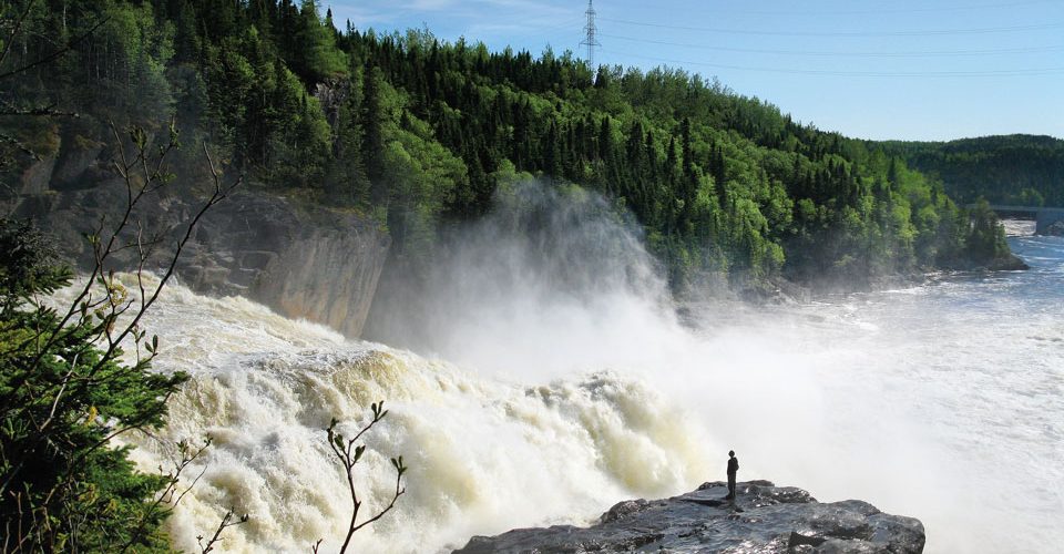
To get to the Grandes Chutes, we had to pass through a Hydro-Québec checkpoint and take the newly constructed gravel road to a wooden bridge just above the falls. The forests had been leveled for as far as the eye could see. Piles of logs stacked in pyramids lined the roadside. Godzilla-like feller bunchers and bulldozers crawled across the denuded hillsides. We hiked over piles of slash until we reached the portage trail. We could hear the thunderous chute before we could see it through the tops of the trees. Climbing over rocks, we followed the river as it made its tumultuous descent before crashing over the precipice. Sheets of mist billowed in the air like sails.
We reached the top of the precipice and stood over a mass of white water, the river basin obscured by clouds of vapour and foam. Scott climbed down a steep rock face and stood perilously at the river’s edge, his tiny silhouette dwarfed by the great cataract. While I experienced that almost ecstatic feeling of being before an incomparable natural spectacle, at the same time I carried the certain knowledge that the river was doomed. Scott and his group continued to fight to save the falls – but the machinery was already nosing its way through the curtains of mist where we stood.
I asked Scott if it was too late to save the Romaine. “Our hope is that in the future it will be politically impossible to dam one of the last wild rivers,” he said. “I’m trying to hold back the oncoming army until reinforcements arrive. We need to get out there and say, we don’t need to take this lying down.”
A year or two from now, I thought, when the salmon return after two or three years and they head upriver toward their gravelly spawning beds in the pools beneath the Grandes Chutes, there will be no more pools.
When it was time to go, it was hard to tear Scott away. “Just give me a moment,” he said.
Afterwards, I went to sit by the last set of rapids on the river before it somersaults over a jumble of rocks into the estuary.
I could see the Innu in their boats and their bright orange jackets, and the islands in the distance. These islands all have Innu names, meaning that they are a part of their history. Iskuekuniskuain. Katshinahkuaht. Ahkan Hukanainh. Names tell the stories of those places – where someone was born, where the fish or caribou were plentiful, where someone was caught in a snowstorm, where a sign was given.
To preserve this history, Innu elders share stories with young people from their communities who want to learn about the old travel routes into the interior, over rivers and lakes by canoe, snowshoe and toboggan. They explain where to look for the mounds of stones under which they cached their meat; where to find the piles of fishing poles that were left at the place on the river when they were no longer needed; where to find depressions in the rocks made by the passage of feet over the millennia. Their place names tell their histories. Memory is geography. Who, then, will the Innu be without their land?
By the summer of 2013, crews had cleared yet more forest for the creation of a third reservoir and hydroelectric complex at kilometre 99. They were asphalting the first stretch of the access road, punching it further inland. At Romaine-2, on target to begin operating in late 2014, the installation of two massive turbines inside a deep underground gallery was underway. Blasting and crushing continued at Romaine-1, the site of the Grandes Chutes, while a spillway, underground powerhouse, tunnels for the penstocks and the temporary river diversion were under construction. Where a living forest so recently stood, photos on Hydro-Québec’s website now show a moonscape of quarries, tunnels, piles of rock and heavy machinery. As you read this, the tempestuous pools where the salmon come to spawn will likely have become a graveyard of rock and sand. All that remains untouched is the site of Romaine-4, the largest of the four reservoirs by far, accounting for more than half of the 279 km2 area that will be flooded by the complex.
The Liberal Party that created Québec’s Plan Nord was replaced by the Parti Québécois in 2012, and the scheme to open up the northlands to industrial development is proceeding under a new name: Le Nord Pour Tous. Dubbed a “carbon copy” of the old by the Liberals, the revised plan emphasizes the “development” objective of its “sustainable development” model by backing out of a commitment to protect 20 per cent of the project area – a landscape twice the size of France.
On May 27, 2013, a Québec Superior Court rejected the Uashat and Mani-Utenam band’s motion to halt work on the power lines, which were under construction even while the court’s decision was pending. Band Council Chief Mike MacKenzie stated that his community would continue to press for justice. “Is this what we can expect,” he asked, “from the new Plan Pour Nous?”
On the last morning of our visit, Vollant and a dozen others began another march. This time they were marching north, towards the Romaine. Before setting out, a large group gathered inside the shaputuan to see them off. They danced and prayed together, then filtered out onto Route 138 and dispersed. Only a few remained who would march with Vollant, dressed in fluorescent vests. They planned to stop at the Innu communities along the way, gathering signatures for a petition stating their opposition to the Plan Nord.
After walking for six days, the marchers arrived at the Romaine construction site and were joined by Innu from nearby communities as well as by Québécois supporters from the region. Some 50 protesters formed a human chain before the entrance to the site where they held their ground for 11 hours.
Vollant was full of hope on that summer day in 2012. She felt that while the Romaine may be ruined, there is still much work to do to protect what remains of Nitassinan from Plan Nord, which calls for adding another 3,500 megawatts of hydroelectric energy to the 47,000 already produced by the province. Next will be the Petit-Mecatina River – currently under study, with construction scheduled to begin in 2015 – and after that the Magpie and a half-dozen other, smaller rivers, opening up the boreal forests for mining and forestry projects, and an influx of newcomers throughout the region. “The Innu people are coming together,” Vollant said. “The young people are rising up. People from outside – like yourself – will come to join us in solidarity.”
After walking with them for two hours, I had to turn around to begin the journey home. I watched Vollant and her group walking at a good clip into the distance, until they disappeared beyond the 50th parallel, into the unspoiled boreal.
Alexis Lathem is a poet, journalist and writing instructor.